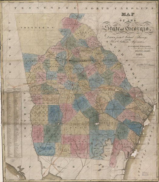
File:Georgia 1830 State Map.jpg
Jump to navigation
Jump to search

Size of this preview: 524 × 600 pixels. Other resolutions: 210 × 240 pixels | 1,642 × 1,879 pixels.
Original file (1,642 × 1,879 pixels, file size: 727 KB, MIME type: image/jpeg)
Citation
Source Listing
Wellborn, Carlton, Orange Green, and William Hoogland. Map of the state of Georgia, drawn from actual surveys and the most authentic information. [S.l.: s.n, 1830] Map. Retrieved from the Library of Congress, https://www.loc.gov/resource/g3920.tr000287/. (Accessed January 04, 2018.)
Citation Listing
Citation:Georgia 1830 State Map.jpg/Citation Listing
Subsequent Note
Citation:Georgia 1830 State Map.jpg/Subsequent Note
Link to Citation
- Atlas geographique, statistique, historique et chronologique des deux Ameriques
- Citation:Georgia 1830 State Map.jpg
- Citation:Atlas geographique, statistique, historique et chronologique des deux Ameriques/Source Listing
- Citation:Georgia 1830 State Map.jpg/Citation Listing
- Citation:Georgia 1830 State Map.jpg/Subsequent Note
Wiki Codes
 Source Listing:
 {{Citation:Atlas geographique, statistique, historique et chronologique des deux Ameriques/Source Listing}}
 Citation Listing:
 {{Citation:Geographical, Historical, And Statistical Map Of Georgia.jpg/Citation Listing}}
 Subsequent Note:
 {{Citation:Geographical, Historical, And Statistical Map Of Georgia.jpg/Subsequent Note}}
Reports
- {{#l:dlink|Georgia 1830 State Map.jpg}}
Notes
Transcription
Places in this Document
File history
Click on a date/time to view the file as it appeared at that time.
| Date/Time | Thumbnail | Dimensions | User | Comment | |
|---|---|---|---|---|---|
| current | 07:55, 10 April 2013 | | 1,642 × 1,879 (727 KB) | Wikiadmin (talk | contribs) | MsUpload |
You cannot overwrite this file.
File usage
The following page uses this file: